
HAPS vs GEO Satellites: Which Wins on Latency, Coverage, and Cost?
HughesNet median latency: 683ms. A HAPS at 20km: under 1ms. The gap is physics, not engineering, and it is permanently disqualifying for GEO.


Stratosphere or Geostationary Belt? A Comparative Analysis of High Altitude Platform Stations and GEO Satellites for Low Latency Connectivity
1. Summary
The architecture of global non-terrestrial connectivity is undergoing the most consequential restructuring since the launch of Intelsat I (Early Bird) in 1965 [1][2]. Two airborne layers, separated by roughly four orders of magnitude in altitude, are now competing for overlapping addressable markets while simultaneously redefining the role each can credibly play. Geostationary Earth Orbit (GEO) satellites, occupying the equatorial belt at 35,786 km, remain the proven workhorse of long-haul broadcast, maritime, aeronautical, and rural broadband connectivity. High Altitude Platform Stations (HAPS), operating in the stratosphere between approximately 18 and 25 km, have transitioned in the past five years from a recurring research curiosity into a pre-commercial industry, with multi-month flight endurance demonstrated in 2025, and pre-commercial revenue contracts signed for 2026 deployments [3][4][5].
The single most important comparative axis between the two is propagation latency. The theoretical one-way propagation delay to a GEO satellite at zenith is approximately 119 ms, rising to roughly 125 to 140 ms at low elevation, with measured end-to-end round-trip times for operational consumer GEO services such as HughesNet and Viasat persistently in the 600 to 700 ms range as of early 2025 [6][7][8]. HAPS, by contrast, exhibit one-way propagation delay between approximately 0.06 and 0.17 ms, with round-trip propagation in the 0.13 to 0.33 ms range, before processing overhead is added [9]. End-to-end measured HAPS latency, demonstrated in field trials by SoftBank and others, is comparable to terrestrial 4G/5G base stations because the platform functions effectively as an aerial gNodeB [10][11]. This three orders-of-magnitude gap is not an engineering artifact that incremental GEO innovation can close; it is a function of the speed of light over distance, and it permanently disqualifies GEO for any application where round-trip times below approximately 150 ms are operationally required.
This report finds that HAPS and GEO are best understood not as direct substitutes but as architectures with overlapping, partially complementary, and partially competitive niches. GEO retains structural advantages in continental-scale broadcast coverage, mature regulatory frameworks, predictable 15-year operational lifetimes, and very high capacity per spacecraft. Available data points toward GEO unit economics in the range of USD 150 to 500 million in deployment capital expenditure per spacecraft, plus roughly USD 80 to 110 million in launch costs, amortized over a 15-year operational life [12][13][14]. HAPS unit economics are far less settled, with Loon disclosing replacement balloon costs in the tens of thousands of dollars on five-month replacement cycles before its 2021 shutdown [15], while next-generation fixed-wing platforms such as Aalto's Zephyr have demonstrated 67-day continuous flights as of April 2025 [3], and Sceye's airships have demonstrated 12-day endurance with sub-1-kilometer station keeping in 2026 [4].

The most consequential strategic shift is that Low Earth Orbit (LEO) constellations, principally Starlink, have already absorbed much of the latency-sensitive demand that GEO operators historically tolerated as their natural ceiling. The consequence is twofold: GEO operators are repositioning toward backhaul, broadcast, mobility, and government services where latency tolerance and persistent coverage matter more than interactivity; and HAPS are repositioning as a regional, sovereign, and resilience-oriented complement rather than as a global-scale connectivity layer in their own right. The 2025 strategic investment by SoftBank in Sceye, with exclusive Japanese rights for pre-commercial HAPS service in 2026, exemplifies this repositioning [5].
Regulatory progress at the World Radiocommunication Conferences of 2019 and 2023 has substantially expanded usable HAPS spectrum, including identifications in the 6, 21, 24, 31, 38, and 47/48 GHz bands and, for HAPS as IMT base stations (HIBS), in the 2 GHz, 2.6 GHz, 700 to 900 MHz, and 1.7 GHz bands [16][17][18]. National aviation authority frameworks, by contrast, remain immature; the Joint Authorities for Rulemaking on Unmanned Systems (JARUS) approved a draft CS-HAPS airworthiness specification only in 2024 [19][20]. This asymmetry, with mature international regulation for spectrum but adolescent regulation for airspace integration, is the principal commercial bottleneck for HAPS at scale.
Three principal recommendations follow from the analysis. First, telecommunications operators should treat HAPS not as a GEO substitute but as a regional resilience and IMT-coverage extension layer integrated within a 3GPP Release 17 / 18 non-terrestrial network framework. Second, defense planners should accelerate dual-use procurement of HAPS for theater-level intelligence, surveillance, reconnaissance, and tactical communications backhaul, where the latency, persistence, and recoverability profile materially exceeds that of GEO assets. Third, institutional investors should price HAPS opportunities against a longer regulatory and certification timeline than current marketing materials suggest, and recognize that GEO operators retain considerable runway in non-latency-sensitive verticals notwithstanding LEO competition. Geopolitical and sovereignty considerations, particularly for states in the Global South and middle powers seeking alternatives to dependence on a small number of foreign-controlled GEO operators or LEO constellations, materially strengthen the policy case for indigenous or regional HAPS programs, even where pure economic logic remains contested.
1. Summary
2. Contextual Background and Historical Development
2.1 The Sixty-Year Maturation of GEO Communications
2.2 The HAPS Renaissance
2.3 The 3GPP Inflection
3. Key Players and Stakeholders
3.1 Commercial Operators and Manufacturers
3.2 Governmental and Military Stakeholders
3.3 Regulatory Bodies
3.4 Capital Providers
4. Technical and Operational Considerations
4.1 Propagation Delay: The Defining Asymmetry
4.2 Link Budget, Coverage, and Capacity
4.3 Frequency Allocations and Beam Geometry
4.4 Station-Keeping, Persistence, and Payload Constraints
4.5 Atmospheric Effects, Handover, and NTN Integration
5. Economic and Market Dynamics
5.1 Capital Expenditure and Operating Cost Structures
5.2 Replacement Cycles and Total Cost of Ownership
5.3 Addressable Markets and Revenue Models
5.4 Competitive, Complementary, and Structurally Advantaged Domains
6. Regulatory Landscape
6.1 ITU Spectrum Framework
6.2 Aviation Authority Frameworks
6.3 Cross-Border Operational Issues
6.4 Regulatory Asymmetry
7. Geopolitical and Strategic Dimensions
7.1 Sovereignty and Dependence
7.2 Dual-Use and Military Interest
7.3 Strategic Competition
7.4 Implications for Digital Sovereignty
8. Risk Analysis
8.1 Short-Term Horizon (1 to 3 Years)
8.2 Medium-Term Horizon (3 to 7 Years)
8.3 Long-Term Horizon (7+ Years)
9. Strategic Recommendations
9.1 Recommendations for Telecommunications Operators and Network Architects
9.2 Recommendations for Defense and National Security Planners
9.3 Recommendations for Institutional Investors and Capital Allocators
9.4 Recommendations for Policymakers and Regulators
10. References
2. Contextual Background and Historical Development
2.1 The Sixty-Year Maturation of GEO Communications
The GEO concept, articulated by Arthur C. Clarke in 1945, achieved commercial reality on 6 April 1965 with the launch of Intelsat I, nicknamed Early Bird, by NASA on behalf of the Communications Satellite Corporation [1][2]. Built by Hughes Aircraft and derived from the Syncom demonstrators, Early Bird carried 240 voice circuits or one television channel and operated for nearly four years before being placed in orbital reserve [1][2]. The five decades that followed produced a relatively orderly progression: Intelsat IV through Intelsat VI introduced multi-beam architectures and increased capacity; the 1980s and 1990s saw direct broadcast satellite television emerge as a dominant revenue stream for SES, Eutelsat, and DirecTV; the 2000s ushered in high-throughput satellites (HTS) using spot-beam architectures from Viasat, Hughes, and Inmarsat. The most recent generation, exemplified by Jupiter-3 launched by EchoStar in 2023 and Viasat-3 launched in 2023, push throughput per satellite into the hundreds of gigabits per second range while retaining the underlying GEO architecture [21].
The structural latency penalty of GEO has been understood since Early Bird, but until the 2020s no scaled alternative existed for residential and small-business broadband. That changed with the LEO inflection. Operational measurements by Ookla in the first quarter of 2025 placed HughesNet median multi-server latency at 683 ms and Viasat median latency at 684 ms, against Starlink's 45 ms [6][8]. The competitive consequence has been pronounced: HughesNet and Viasat have lost subscribers steadily since 2022, while Starlink's subscriber base has grown rapidly in the same period [6][8].
2.2 The HAPS Renaissance
HAPS is not a new concept. ITU studies of high-altitude platforms began around 1996, and the International Telecommunication Union formally defined HAPS in the Radio Regulations as stations located at altitudes of 20 to 50 km at fixed nominal positions relative to Earth [16][22]. NASA's Pathfinder and Helios solar aircraft of the late 1990s and early 2000s, together with Japan's JAXA Stratospheric Platform program, established baseline feasibility but did not produce sustained commercial deployment. Loon, incubated within Google X from 2011 and operationalized as an Alphabet subsidiary in 2018, brought stratospheric balloon connectivity to commercial trials in Kenya and emergency deployment in Puerto Rico after Hurricane Maria in 2017, but was wound down in January 2021 after Alphabet concluded the unit could not achieve sustainable unit economics [15][23].

The post-Loon period has been characterized by industrial consolidation and accelerated technical maturation. Airbus's Zephyr program, originally a QinetiQ project acquired by Airbus and now operated through subsidiary AALTO, completed a record 67-day continuous stratospheric flight ending 28 April 2025, surpassing its prior 64-day record from 2022 and breaking a half century world record for longest aircraft flight [3][24]. BAE Systems' Prismatic subsidiary advanced its PHASA-35 platform through 24-hour stratospheric flights at over 66,000 feet at Spaceport America in 2023 and 2024, with operational entry targeted for 2026 to 2027 [25][26]. Thales Alenia Space's Stratobus airship, in development since 2010, is now constructing reduced-scale demonstrators within the European Defence Fund's EuroHAPS project, alongside Italian CIRA's Hybrid High Altitude Airship and ESG/TAO's altitude-controllable balloon system [27][28]. SoftBank's HAPSMobile/Sunglider, a 78-meter wingspan solar UAS developed with AeroVironment, achieved its first stratospheric flight in September 2020 and was used in a U.S. Department of Defense field trial in August 2024 [10][29].
Sceye, a New Mexico-based airship developer, completed a 12-day, 6,400-mile stratospheric flight from New Mexico to Brazil in early 2026, achieving a station-keeping radius as low as 1 km [4]. SoftBank purchased a Sceye pre-commercial demonstration flight for Japan in 2026 and made a Series C equity investment in Sceye in June 2025, securing exclusive Japanese deployment rights [5][30]. Other notable programs include Stratospheric Platforms Ltd. in the United Kingdom, working with Deutsche Telekom; Avealto, an airship developer; and India's DRDO, which conducted a maiden flight of a stratospheric airship platform at Sheopur in May 2025, reaching 17 km [31].
2.3 The 3GPP Inflection
The decisive technical inflection for both GEO and HAPS in connectivity markets was the integration of non-terrestrial networks into 3GPP cellular standards. 3GPP Release 17, frozen in 2022, included the first normative specifications for 5G New Radio over satellite and HAPS, with Release 18 extending support to NB-IoT and eMTC for IoT-NTN, and Release 19 currently developing regenerative payload, store-and-forward, and improved mobility features [32][33] [34]. Critically, Release 17 established that "NR UEs as defined by TS 38.101-1 can support HAPS deployments with no additional changes," positioning HAPS as the closest non-terrestrial layer to the existing terrestrial cellular ecosystem from a device perspective [32]. This standards posture transformed both GEO and HAPS from proprietary niche services into integrated components of a heterogeneous mobile network.
3. Key Players and Stakeholders
3.1 Commercial Operators and Manufacturers
On the GEO side, the operator landscape consists of a handful of incumbents commanding the bulk of global capacity: Intelsat (now operating in the wake of its 2023 Inmarsat acquisition reversal and merger discussions with SES), SES, EchoStar/Hughes, Viasat, Eutelsat (post OneWeb merger), and Telesat. The manufacturer base is similarly concentrated, with Airbus Defence and Space, Thales Alenia Space, Boeing, Lockheed Martin, Northrop Grumman, and Maxar accounting for the overwhelming majority of GEO platform deliveries. Average GEO procurement costs have been estimated at USD 150 to 500 million per spacecraft, with fully loaded program costs commonly exceeding several hundred million dollars including launch, insurance, and gateways [12][13]. Smaller GEO challengers, notably Astranis, are pursuing software-defined small GEO platforms aimed at sovereign customers, with K2 Space pursuing a higher-power architecture to compete on dollar-per-megabit metrics [14].
On the HAPS side, the field is more fragmented but contains identifiable leaders. Aalto (Airbus subsidiary), BAE Systems Prismatic, Thales Alenia Space (Stratobus), SoftBank (with absorbed HAPSMobile), AeroVironment, Sceye, and Stratospheric Platforms Ltd. constitute the principal Western developers, with the HAPS Alliance, founded in 2020 by SoftBank, Loon, AT&T, Nokia, Ericsson, T-Mobile, and others, serving as the industry's standards and advocacy forum [22][35]. Chinese developers including the Aviation Industry Corporation of China (AVIC), CASIC, KuangChi Science, and Beihang University have advanced multiple programs, most prominently the Yuanmeng airship tested in 2015 [36][37].
3.2 Governmental and Military Stakeholders
The U.S. Department of Defense has maintained sustained interest in stratospheric platforms, dating to DARPA's Integrated Sensor is Structure program of the late 2000s, which envisaged a stratospheric airship with embedded radar of more than 6,000 square meters for ballistic and cruise missile defense [38]. DARPA's ALTA program subsequently developed wind prediction sensors to enable persistent stratospheric balloon station-keeping [39]. The August 2024 trial in which AeroVironment flew SoftBank's Sunglider for the U.S. Department of Defense in New Mexico signals continued operational interest [29]. The U.S. Army Space and Missile Defense Command sponsored BAE PHASA-35 flights at White Sands Missile Range [25].
Allied programs include the United Kingdom's investment in Prismatic/PHASA-35 through BAE Systems and FalconWorks; France and Italy through Thales Alenia Space's Stratobus and the European Defence Fund's EuroHAPS consortium, which involves defense ministries from France, Italy, Spain, Germany, Hungary, and the Czech Republic [27]; Japan through SoftBank and METI's research support; and India through DRDO's Aerial Delivery R&D Establishment [31]. The Joint Air Power Competence Centre, a NATO-aligned think tank, has assessed HAPS as offering "advantages [that] stem from the operating altitude and the specific design, the result of combining the flexibility of aircraft (including UAVs) with the endurance of satellites," with applications in tactical reconnaissance, communications relay, and beyond-line-of-sight UAV operations [40].
Chinese military interest has been documented through the Yuanmeng airship of 2015, which defense analysts have assessed as capable of detecting stealth aircraft, cruise missiles, and warships at ranges of several hundred kilometers, and serving as a communications relay in the event of satellite communications loss [36][37]. Imagery published in 2023 of a large hangar in Xinjiang and an apparent airship over the South China Sea suggested continued Chinese stratospheric airship development [37].
3.3 Regulatory Bodies
The International Telecommunication Union, through the Radiocommunication Sector (ITU-R) and World Radiocommunication Conferences, governs spectrum allocations for both GEO and HAPS. The International Civil Aviation Organization (ICAO) coordinates higher-airspace operations, with an emerging concept of "Higher Airspace Operations Traffic Management" (HAO-TM) under development through the HAPS Alliance and ICAO [41]. National civil aviation authorities, principally the U.S. Federal Aviation Administration, the European Union Aviation Safety Agency (EASA), the United Kingdom Civil Aviation Authority, the Kenya Civil Aviation Authority (which authorized Aalto's Aaltoport in Laikipia County in 2024), and counterpart bodies, provide airworthiness certification [3][42]. The Joint Authorities for Rulemaking on Unmanned Systems (JARUS) approved its CS-HAPS airworthiness specification, version 1.0, in 2024 [19][20].
3GPP serves as the principal global standards body for HAPS-cellular integration; ETSI, GSMA, and ATIS contribute to ITU-R submissions on behalf of 3GPP [33][43]. The HAPS Alliance, founded in 2020, has issued certification pathway recommendations and regulatory white papers [42].
3.4 Capital Providers
Institutional capital flows to HAPS have remained modest by satellite-industry standards. SoftBank has been the most consistent strategic investor, funding HAPSMobile, the Loon HAPSMobile interoperability work prior to Loon's wind-down, and most recently Sceye's Series C in 2025 [5][15]. Sceye has additionally drawn investment from Mawarid Holding Company and América Móvil [4]. Airbus has funded Aalto/Zephyr internally, while BAE Systems funds Prismatic. NSR and Euroconsult (now Novaspace) provide the principal commercial market analysis; NSR's third edition HAPS report forecast USD 2.6 billion in cumulative HAPS revenues over the decade ending 2028, with balloons forecast as the dominant unit-volume segment until the 2022 Loon shutdown shifted that mix toward heavier-than-air platforms [44]. More recent forecasts from MarkNtel place the global HAPS market at approximately USD 99 million in 2024, growing to USD 240 million by 2030 at a 16% CAGR; the Frontex/EU report observes that HAPS in-service unit numbers were anticipated to decline at a 7.1% CAGR through 2029 in the post Loon environment [45][46]. These figures should be treated as illustrative; market sizing for HAPS is unsettled and analyst estimates diverge materially.
4. Technical and Operational Considerations
4.1 Propagation Delay: The Defining Asymmetry
The single fact that orders the entire comparison between HAPS and GEO is the difference in propagation distance. The GEO orbital altitude of 35,786 km gives a one-way propagation delay of approximately 119 ms at zenith and 125 to 140 ms at the edge of coverage where slant range increases [7]. Round-trip propagation is therefore 240 to 280 ms minimum. End-to-end round trip times measured on operational consumer GEO services typically run 480 to 700 ms, with the additional delay attributable to ground gateway processing, terrestrial transit, modem framing, and forward error correction [6][7][47]. Industry measurements from VSAT operators indicate approximately 500 ms of additional latency beyond pure propagation due to "processing delays from the network and teleport equipment" [48]
A HAPS operating at 20 km has a one-way propagation delay of approximately 0.067 ms at zenith. Even at low elevation angles giving slant ranges of approximately 50 km, one-way delay remains below 0.17 ms. Published academic measurements place HAPS round-trip propagation between approximately 0.13 and 0.33 ms [9]. Field trial results from SoftBank's June 2025 Hachijō Island demonstration (using a light aircraft at 3,000 m as a HAPS surrogate) achieved end-to-end 5G connectivity comparable to terrestrial deployment [11]. In NTN architecture comparisons, HAPS round-trip latency has been characterized as 0.1 to 1 ms, against 4 to 40 ms for LEO and approximately 540 ms for GEO at the air interface alone [33][49].
The operational consequence is categorical. Applications with hard latency budgets below 150 ms one-way—including real-time voice (perceptible degradation above 150 ms), interactive video conferencing, online gaming, certain financial transactions, military command and control of weapons systems, and tactile internet applications, are commercially or operationally disqualifying for GEO service. Viasat estimates that fewer than 10% of internet traffic is genuinely latency-sensitive, but that 10% includes most of the workloads consumers most readily perceive as "broken" on satellite [47]. Conversely, broadcast video, bulk file transfer, store-and-forward IoT messaging, email, web browsing with TCP acceleration, and most enterprise VPN backhaul tolerate GEO latency without operational consequence.
4.2 Link Budget, Coverage, and Capacity
The link budget contrasts are the inverse of the latency contrasts. Free-space path loss to a HAPS at 20 km is approximately 147 to 155 dB at typical frequencies, against 169 to 175 dB for LEO and 175 to 187 dB for GEO [9]. This roughly 30 dB advantage permits HAPS to communicate directly with standard, unmodified mobile handsets, whereas GEO direct-to-device communication requires either very large phased-array satellite antennas (as in the AST SpaceMobile BlueBird approach) or specialized terminals. SoftBank's Sunglider demonstrated direct LTE connectivity to standard smartphones from 19 km altitude in 2020 [10], and field trial work has demonstrated multi-cell payloads with 6-cell footprint coverage targeting service areas up to 200 km in diameter [11][50].
GEO's coverage geometry is the inverse: a single GEO satellite covers roughly one-third of the Earth's surface, enabling near-global continuity with three operational spacecraft. A HAPS operating at 20 km covers an area of approximately 50 to 200 km diameter depending on elevation-angle assumptions and antenna design [9][50]. Continental-scale HAPS coverage therefore requires fleets: HAPSMobile estimated 40 Sunglider aircraft to cover the Japanese archipelago [29]. Capacity per dollar comparisons are strongly application-dependent. Modern high-throughput GEO satellites such as ViaSat-3 and Jupiter-3 deliver hundreds of Gbps to terabit-class capacity per spacecraft, against an estimated USD 400 to 700 million fully loaded program cost [12][13] [14]. HAPS unit capacity is more modest, generally in the low-Gbps range per platform, but per platform capital cost is one to two orders of magnitude lower; Loon disclosed costs per balloon in the tens of thousands of dollars [15], while next-generation platforms such as Zephyr and PHASA-35 fall in a higher range without published unit pricing.
4.3 Frequency Allocations and Beam Geometry
WRC-19 identified the 31-31.3 GHz and 38-39.5 GHz bands worldwide for HAPS, confirmed the 47.2-47.5 GHz and 47.9-48.2 GHz bands worldwide, and identified the 21.4-22 GHz and 24.25 27.5 GHz bands for HAPS in ITU Region 2 (the Americas) [17][51]. Earlier WRCs had designated the 47/48 GHz, 2 GHz, 27/31 GHz, and 6 GHz bands for HAPS [22]. WRC-23 expanded HAPS access to International Mobile Telecommunications (IMT) bands, including 694-960 MHz, 1.7 GHz, 2 GHz, and 2.6 GHz for HAPS-as-IMT-base-stations (HIBS), with regulatory conditions for HIBS commercial availability in some Asia-Pacific countries by 2025 [18][52]. ITU-R Report F.2438 estimates total spectrum needs in the fixed service for HAPS systems at 396 to 2,969 MHz for ground-to-platform links and 324 to 1,505 MHz for platform-to-ground links [16].
GEO spectrum allocations are mature and global, principally in C-band (4/6 GHz), Ku-band (12/14 GHz), and Ka-band (20/30 GHz), with Q/V band (40/50 GHz) increasingly used for feeder links. Coordination between GEO and HAPS in shared bands (notably 24.25-27.5 GHz and 38 39.5 GHz, which overlap fixed-satellite service allocations) requires geographical or directional separation; ITU-R sharing studies indicate coexistence is feasible with basic coordination [53].
4.4 Station-Keeping, Persistence, and Payload Constraints
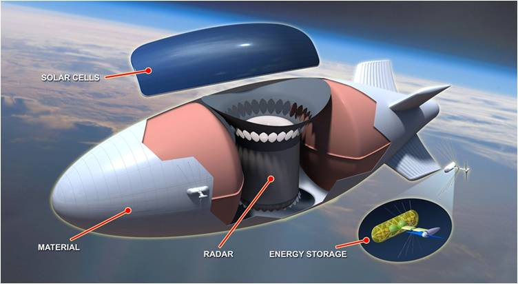
GEO satellites maintain orbital position through station-keeping thrusters with relatively predictable propellant budgets across a 15-year operational life. HAPS station-keeping is the architecture's central operational challenge. Stratospheric winds, while typically less severe than tropospheric jet streams, vary substantially with latitude, season, and the quasi-biennial oscillation. Lighter-than-air HAPS such as Loon balloons, Sceye, and Stratobus require either active propulsion or wind-layer altitude shifting to maintain position. Loon's approach used altitude variation to ride favorable wind layers, achieving navigation but not true geostationary positioning over a target area [15][54]. Sceye's airship-based approach demonstrated a station keeping radius as low as 1 km during its 2026 endurance flight, using continuous solar-powered electric propulsion [4]. Fixed-wing solar HAPS such as Zephyr and PHASA-35 navigate by flying patterns (loiters, figure-8s) within an assigned area.
Payload mass and power are tightly constrained. PHASA-35 carries up to 15 kg of payload [25] [55]. Zephyr is similarly constrained at small payloads of single-digit kilograms. Larger lighter than-air platforms can carry materially more: Sunglider can host 75 kg payloads, Sceye's SE2 is designed for substantially larger payloads, and full-scale Stratobus is targeted at 250 kg payloads at 5 kW [10][27]. By comparison, modern GEO satellites carry payloads measured in the thousands of kilograms with power budgets of 10 to 25 kW.
Persistence has been the most contested HAPS metric. Aalto's Zephyr 67-day flight in 2025 establishes the current outer envelope for fixed-wing solar HAPS [3]. Sceye has demonstrated 12-day continuous flight and is targeting multi-month operations [4]. Loon disclosed a record 312-day balloon flight in 2020 [15]. PHASA-35's "Block 20" generation is being designed for multi-day to multi-week operations [55]. None of these approach the 15-year operational design life of a modern GEO satellite. The replacement-cycle implication is that any continuous HAPS service requires an operational fleet with rotating maintenance cycles, materially complicating the per-platform unit economics.

4.5 Atmospheric Effects, Handover, and NTN Integration
GEO Ka-band and higher-frequency links experience rain attenuation and atmospheric absorption that can create outages of seconds to minutes during severe weather. HAPS, operating above approximately 99% of the atmosphere by mass, suffer relatively less atmospheric attenuation on the downlink, although the troposphere transit during ascent and descent remains the highest-risk operational phase, as Aalto and BAE engineers have explicitly identified [3][56]. PHASA-35 trials in 2024 incorporated UK Met Office weather modeling and LIDAR atmospheric scanning to optimize ascent through the troposphere [55].
Handover dynamics differ sharply from LEO. A LEO satellite at 550 km moves at approximately 7.5 km/s and must hand off active sessions every several minutes; Starlink measurements have identified a 15-second periodic latency structure with handover-induced spikes [57]. GEO satellites are functionally fixed and require no in-flight handover. HAPS, being quasi-stationary, similarly avoid the handover overhead of LEO. This is one of the underappreciated advantages of HAPS in the comparative landscape: a HAPS-served device experiences mobility patterns essentially identical to a terrestrial cellular device.
3GPP Release 17 NTN specifications are the architectural backbone for HAPS-cellular integration. The standard adapts timing advance, Doppler pre-compensation, HARQ behavior, and protocol timers to the latency and motion characteristics of each NTN node class [32][33] [34]. For HAPS specifically, the timing advance and Doppler challenges are minimal compared with LEO, simplifying the device-side adaptations. Release 18 introduces NTN-IoT enhancements, NB-IoT and eMTC over satellite, and store-and-forward operations using regenerative payloads [33][34]. Release 19 work on regenerative payloads, improved feeder-link switchover, and inter-operator NTN roaming will further integrate HAPS into the cellular ecosystem.
5. Economic and Market Dynamics
5.1 Capital Expenditure and Operating Cost Structures
GEO unit economics are well documented. An average GEO satellite procurement, including manufacturing, launch, insurance, and gateway stations, ranges from USD 150 to 500 million, with launch costs typically USD 80 to 110 million additional, and full program costs commonly USD 400 to 700 million [12][13][14]. Operational lifetimes of 15 years amortize this capital over a long horizon. Per-Gbps capital costs for high-throughput GEO satellites have been declining through successive generations, but the Aerospace America assessment that "if you pay USD 300 million for a communications satellite that only gives you 5 kilowatts of throughput, the business case doesn't close on a dollar-per-megabit basis" reflects the competitive pressure on traditional GEO economics from LEO constellations [14].
HAPS unit economics are far less settled. Loon's disclosed cost structure included balloons in the tens of thousands of dollars, replaced approximately every five months, against a reported burn rate of approximately USD 100 million per year for the unit, which Alphabet ultimately judged commercially unviable [15]. Modern fixed-wing HAPS such as Zephyr and PHASA-35 are higher-unit-cost platforms designed for multi-month or multi-year service lives, with Aalto's Zephyr platform incorporating Lincad lithium-ion battery packs and Amprius silicon anode batteries that have powered 67-day continuous operations [3][55][58]. Public unit cost figures are not disclosed, but available materials suggest fixed-wing HAPS unit procurement costs are likely in the low millions of dollars, with operating costs dominated by ground operations, regulatory compliance, and replacement cycles. Lighter-than-air platforms such as Stratobus targeted longer mission durations of up to one year per mission with five-year operational lives [27].
A direct capacity-per-dollar comparison is difficult because the architectures address different geometries. For continental broadcast and broadband to a population dispersed across million square-kilometer service areas, GEO retains a capacity-per-dollar advantage at the system level. For regional coverage of populated corridors of 100 to 200 km diameter, HAPS may achieve favorable capacity per dollar, particularly when integrated with terrestrial 5G mobile network operator infrastructure as a coverage extension layer rather than a standalone service.
5.2 Replacement Cycles and Total Cost of Ownership
The replacement cycle differential is structurally important. A GEO satellite's 15-year operational life amortizes acquisition and launch capex across more than 130,000 operational hours. A 67-day HAPS flight is approximately 1,600 operational hours, requiring roughly 80 such flights to match a single GEO operational lifetime. Even setting aside acquisition cost differentials, this implies that HAPS total cost of ownership analysis must account for substantially more frequent recovery, refurbishment, and relaunch operations than GEO. The countervailing advantage is that HAPS recovery enables payload upgrades, repairs, and reconfiguration that are impossible for an in-orbit GEO satellite, which has implications for technology refresh rates and service evolution.
5.3 Addressable Markets and Revenue Models
GEO operators serve five principal segments: broadcast video distribution; consumer and small business broadband in underserved areas; government and military fixed satellite services; mobility (maritime, aeronautical, land); and trunking / backhaul for terrestrial telecommunications. Of these, broadcast remains the largest GEO revenue contributor globally, although its long-term trajectory is structurally challenged by streaming substitution. Consumer broadband in underserved areas is the segment most acutely under competitive pressure from LEO, evidenced in HughesNet and Viasat subscriber declines [6][8].
HAPS-targeted markets are more emergent and more fragmented. The principal use cases are: rural and remote broadband coverage extension for mobile network operators (the SoftBank Sceye and Aalto-mobile-operator partnerships exemplify this) [5][30]; emergency communications and disaster recovery (a use case demonstrated by Loon during Hurricane Maria and central to the Sceye-SoftBank Japanese earthquake recovery rationale) [5][15]; military and intelligence ISR (the dominant near-term commercial revenue driver, accounting for the highest revenue share in the high-altitude platform market according to Grand View Research) [59]; environmental monitoring including methane emissions detection (Sceye's contracted relationship with the U.S. Environmental Protection Agency) [60]; and IoT and Earth observation backhaul.
5.4 Competitive, Complementary, and Structurally Advantaged Domains
HAPS and GEO compete most directly in two domains: rural and remote broadband, where both can deliver service to populations beyond terrestrial network reach; and government and military communications, where both can deliver wide-area coverage. They complement most strongly in: heterogeneous network architectures where GEO provides continental-scale broadcast and HAPS provides regional latency-sensitive overlay; in disaster recovery where GEO provides immediate continental reachback while HAPS can be repositioned for sustained local connectivity restoration; and in 5G and 6G non-terrestrial network architectures where each layer (terrestrial, HAPS, LEO, MEO, GEO) addresses a different combination of latency, capacity, and coverage requirements [33][49][61].
GEO is structurally advantaged for: continental and oceanic broadcast distribution where multicast efficiency dominates; mobility services for aircraft and ships traversing oceanic regions; and any application where regulatory maturity, predictable 15-year operational lifetimes, and established orbital slot rights matter more than latency. HAPS are structurally advantaged for: IMT-coverage extension over populated rural areas where the platforms can be integrated into 3GPP NTN frameworks with no device-side modifications; ISR and tactical communications where recoverability and payload swapping matter; and regional sovereign deployments where avoiding dependence on a small number of foreign-controlled GEO operators is a primary policy objective
6. Regulatory Landscape
6.1 ITU Spectrum Framework
The ITU regulatory framework for HAPS has evolved through five WRC cycles. WRC-97, WRC 2000, and WRC-12 designated HAPS spectrum at 47/48 GHz, 2 GHz, 27/31 GHz, and 6 GHz [22]. WRC-19 added worldwide identifications at 31-31.3 GHz and 38-39.5 GHz, confirmed worldwide use of 47.2-47.5 GHz and 47.9-48.2 GHz, and added Region 2 (Americas) identifications at 21.4-22 GHz and 24.25-27.5 GHz [17][22]. WRC-23 added the 694-960 MHz, 1.7 GHz, 2 GHz, and 2.6 GHz IMT bands for HAPS-as-IMT-base-stations (HIBS), creating the regulatory foundation for direct integration of HAPS into mobile network operator IMT coverage [18][52]. WRC-23 also addressed HAPS sharing with adjacent fixed-satellite services and protection of incumbent users [16].
GEO regulatory frameworks are mature, with orbital slot allocations administered through ITU coordination procedures and national regulators. The C-band debate in the United States, where the FCC reallocated portions of C-band to terrestrial 5G services in exchange for cash payments to incumbent operators, illustrates the relative stability and tradability of GEO spectrum rights compared with the more nascent HAPS regime.
6.2 Aviation Authority Frameworks
National civil aviation authority frameworks for HAPS remain materially less mature than spectrum frameworks. The FAA, EASA, and counterpart national authorities have generally treated HAPS within unmanned aircraft system frameworks adapted for stratospheric operations. JARUS approved CS-HAPS, an airworthiness specification dedicated to HAPS, only in 2024 [19][20]. The HAPS Alliance's 2024 Certification Pathways white paper observed that "certification may not be the appropriate framework for HAPS" and recommended a "lighter framework that accounts for the lower risk profile and results in some form of system certificate" [42]. EASA indicated at the 2022 ECHO Brussels Conference that civil and commercial HAPS certification in Europe was likely to remain in development through 2030, with a roadmap challenged by industry as too slow [46].
Specific operational authorizations have generally been issued on a case-by-case basis. Aalto secured Kenyan operating permissions in 2024 after 18 months of regulatory engagement with the Kenya Civil Aviation Authority and Kenya Space Agency [3]. PHASA-35 operations have been conducted at FAA-licensed Spaceport America with U.S. Army White Sands Missile Range coordination [25]. Sceye operations have been conducted from Roswell, New Mexico, also with coordinated airspace management.
6.3 Cross-Border Operational Issues
HAPS create cross-border issues distinct from those of GEO satellites. A GEO satellite's orbital slot is assigned through ITU coordination and represents a relatively settled property right. A HAPS operating over national territory or near borders implicates national airspace sovereignty, transit rights, and cross-border interference and surveillance concerns. The 2023 Chinese balloon incidents over U.S. and Canadian airspace, while concerning lower-altitude balloons rather than stratospheric HAPS, raised the political salience of cross-border high-altitude operations [37]. The HAPS Alliance has proposed a "Higher Airspace Operations Traffic Management" (HAO-TM) framework to harmonize cross-border HAPS operations while protecting national sovereignty [41].
6.4 Regulatory Asymmetry
The regulatory asymmetry between mature GEO frameworks and adolescent HAPS frameworks is the principal regulatory bottleneck for HAPS deployment at scale. GEO operators benefit from approximately six decades of accumulated international and national regulatory infrastructure, including ITU coordination procedures, national operating licenses, orbital slot rights, and well-developed spectrum coordination. HAPS operators must construct equivalent infrastructure, often in parallel with technology development and commercial market formation. This asymmetry materially extends HAPS time-to-market and compresses near-term revenue forecasts compared with what pure technology readiness would suggest.
7. Geopolitical and Strategic Dimensions
7.1 Sovereignty and Dependence
GEO satellite communications have historically been dominated by a small number of operators headquartered in the United States, Europe, Japan, and Russia. The consolidation of GEO operators (Intelsat, SES, Eutelsat-OneWeb, Viasat-Inmarsat) has compressed the number of independent providers further. For states and large enterprises in the Global South seeking alternatives to dependence on this concentrated set of providers, the practical alternatives have until recently been limited to dependent commercial relationships, ad hoc national satellite programs (often delivered by Western or Chinese manufacturers), or LEO constellations dominated by SpaceX and Amazon.
HAPS offer a structurally different sovereignty profile. A HAPS deployed within national airspace by a national operator is, in jurisdictional terms, a domestic asset. Unlike a GEO satellite manufactured and operated by a foreign entity from a foreign teleport, a HAPS can be domiciled within the host state's regulatory and operational control. The Kenya-Aalto Aaltoport arrangement [3], India's DRDO program [31], and the SoftBank-Sceye Japan deployment [5] each illustrate variants of this approach. For middle powers and Global South states, HAPS represent a more accessible path to indigenous or domiciled connectivity infrastructure than the comparable GEO satellite procurement and launch capability
7.2 Dual-Use and Military Interest
The dual-use character of HAPS is more pronounced than that of GEO. GEO communications satellites are predominantly commercial assets with discrete government services; military applications generally involve dedicated platforms (the U.S. WGS, AEHF, and MUOS constellations, for example). HAPS, by contrast, exhibit dual-use intrinsically: the same airframe, station-keeping system, and basic flight operations support communications relay, ISR, electronic intelligence, and potentially electronic warfare missions. The Joint Air Power Competence Centre's assessment characterizes HAPS as offering particular utility for "tactical reconnaissance" and "relay between satellites and terrestrial systems, like for beyond line of sight UAVs operations," capable of operating "outside the range of enemy air defences" [40].
The U.S. DoD trial of SoftBank's Sunglider in August 2024 [29], DARPA's longstanding Integrated Sensor is Structure and ALTA programs [38][39], the U.S. Army Space and Missile Defense Command sponsorship of PHASA-35 trials [25], and the European Defence Fund's EuroHAPS consortium of six defense ministries [27] each evidence sustained allied military investment. Russia's interest is documented through reporting on stratospheric platforms, although less publicly developed than Western or Chinese programs.
7.3 Strategic Competition
China's HAPS programs represent the most strategically significant non-Western development. The Yuanmeng airship of 2015 demonstrated Chinese capability to develop large stratospheric airships of 18,000 cubic meters volume, with reported station-keeping endurance of up to six months and roles including stealth aircraft detection, cruise missile early warning, and communications relay [36][37]. The 2018 academic discussion of the Tian Heng platform identified its potential as an "affordable part substitute for a near-earth orbit satellite" able to "eliminate the need for multiple aircraft sorties to sustain continuous on-station keeping" for "earth observation, maritime monitoring, missile warning, communication signal relays" [37]. The hangar facility documented in Xinjiang in 2021 and 2023 imagery suggests continued large scale Chinese stratospheric airship operations [37].
The strategic implication is that HAPS development is now a recognized arena of great-power competition. Western HAPS programs (PHASA-35, Zephyr, Stratobus, Sunglider, Sceye) and Chinese programs (Yuanmeng, Tian Heng, AVIC and CASIC platforms) are advancing in parallel, with limited transparency between them. India's 2025 stratospheric airship test, achieved via DRDO, signals the emergence of a third pole in HAPS development [31]. For Western planners, the analytical assessment that emerges is that HAPS represent both an opportunity to extend Western connectivity and ISR capability and a vector through which adversaries can deploy persistent surveillance and resilient communications outside the range of legacy air defense.
7.4 Implications for Digital Sovereignty
The conceptual reframing of connectivity as critical infrastructure rather than as a private-sector service has rendered architecture choices political. HAPS occupy a strategic middle layer between terrestrial towers and orbital systems, and their integration into national infrastructure policy is being actively considered in jurisdictions including the European Union, Japan, India, and Kenya [62]. The "digital colonialism" critique advanced by Global South policy researchers has emphasized the entrenchment of dependency through connectivity infrastructure dominated by Northern corporations [63]. Whether HAPS materially shift this dynamic depends substantially on whether their development trajectories produce affordable, sovereign deployments accessible to non-Western operators, or whether HAPS development consolidates within the same Western corporate stack that dominates GEO and LEO. The current evidence is mixed: most leading HAPS platforms remain Western-developed, although operations are increasingly distributed (Aalto in Kenya, Sceye supporting SoftBank in Japan, EuroHAPS testing in the Canary Islands)
8. Risk Analysis
8.1 Short-Term Horizon (1 to 3 Years)
Over the next one to three years, the principal HAPS risks are technical and regulatory. Technical risks include continued station-keeping limitations during anomalous wind events, battery and solar cell durability under sustained ultraviolet and ozone exposure, and tropospheric transit losses during ascent and descent (identified by both Aalto and BAE engineers as the highest-risk operational phase) [3][56]. Regulatory risks include slower-than-expected national civil aviation authority approvals, delays in JARUS CS-HAPS implementation by individual member authorities, and the absence of mature higher-airspace operations frameworks. Financial risks include continued dependence on strategic-investor patient capital (SoftBank, Airbus, BAE), with limited near-term cash flow to support standalone unit economics. Adoption risks include uncertainty over mobile network operator willingness to integrate HAPS-as-IMT base stations into commercial networks, given the substantial process and operational changes required.
For GEO, short-term risks center on accelerated subscriber attrition in consumer broadband segments under LEO competition (already evident in HughesNet and Viasat 2022-2025 subscriber data) [6][8]; continued capex pressure as operators face the need to refresh fleets while LEO competition compresses pricing power; and execution risks on in-flight programs such as Viasat-3 (which experienced an antenna deployment anomaly on the F1 satellite, reducing intended capacity) [8].

8.2 Medium-Term Horizon (3 to 7 Years)
Over three to seven years, HAPS face the principal medium-term risk of failing to achieve sustainable unit economics at commercial scale. The Loon precedent is sobering: nine years of development, multiple commercial trials, and partnerships with Telkom Kenya were insufficient to demonstrate viable commercial economics, and Alphabet wound down the unit in 2021 [15]. Whether the next-generation fixed-wing and lighter-than-air HAPS programs can avoid Loon's economic fate is contested and not yet demonstrated. Regulatory risks in this horizon include the complexity of cross-border HAPS operations and the harmonization of national airspace rules. Adoption risks include the possibility that LEO direct-to-device services (Starlink Direct-to-Cell, AST SpaceMobile, Lynk Global) absorb the addressable market for IMT-coverage extension that HAPS targets, leaving HAPS in a structurally smaller niche.

For GEO, medium-term risks include ongoing structural market share losses in consumer broadband, accelerating broadcast video substitution by streaming, and the entry of well capitalized LEO operators into mobility and government segments traditionally served by GEO. The optimistic GEO scenario involves successful repositioning toward backhaul, broadcast headend distribution, government and defense contracts, and complementary capacity within multi-orbit (GEO-MEO-LEO) operator portfolios.
8.3 Long-Term Horizon (7+ Years)
Over the long term, HAPS face the existential risk of being absorbed into a hybrid 6G non terrestrial network architecture in which their distinct value proposition is diluted. If LEO direct to-device matures into reliable continental coverage by the mid-2030s, the HAPS-IMT-coverage extension use case becomes structurally narrower. Conversely, the HAPS opportunity could expand if 6G architectures adopt HAPS as the canonical mid-air node for latency-sensitive, region-bounded services. Defense and intelligence demand for HAPS appears to be more durable than commercial demand and is less dependent on commercial unit economics.
GEO long-term risks include the potential structural decline of single-mission GEO communication satellites in favor of multi-orbit architectures, and the substitution of broadcast video by streaming reaching levels that materially compress GEO broadcast revenue. The countervailing long-term GEO opportunities include continued strength in mobility, oceanic, and oceanic broadcast applications where LEO economics remain less favorable; and continued government and defense fixed satellite services demand. The most likely long-term outcome is a multi-layer non-terrestrial connectivity architecture in which GEO retains a smaller but profitable niche, LEO dominates consumer broadband and direct-to-device, and HAPS occupies a regional, latency-sensitive, dual-use middle layer, with the relative weight of each depending on the pace of LEO direct-to-device maturation and HAPS regulatory and economic progress.
9. Strategic Recommendations
9.1 Recommendations for Telecommunications Operators and Network Architects
Telecommunications operators should treat HAPS not as a substitute for GEO but as a complementary layer integrated within a 3GPP Release 17/18 non-terrestrial network architecture. The practical implication is that mobile network operators considering HAPS partnerships should structure them as IMT-coverage extension and disaster recovery overlays, not as standalone broadband services. The SoftBank-Sceye Japanese deployment for 2026 provides a useful template: HAPS service delivered through a mobile network operator's existing core network, addressing a defined geographic deficiency (mountainous regions, remote islands, post-disaster areas), using exclusive territorial rights and integrated billing and authentication [5]. Operators should evaluate HAPS partnerships against the criterion of incremental coverage and resilience value relative to the alternative of additional terrestrial macro-cells, not against the criterion of replacing existing satellite portfolios.
Network architects should anticipate that HAPS-IMT integration will materially expand throughout the late 2020s and design 5G-Advanced and 6G core network architectures to accommodate HAPS as a native NTN node class, with associated handover, roaming, and billing capabilities. GEO portfolios should be reassessed against a continued structural decline in consumer broadband and a relatively durable position in broadcast, mobility, and government segments. Multi-orbit strategy (GEO + MEO + LEO) is advisable for any operator seeking to retain enterprise and government customers across the full latency spectrum.
9.2 Recommendations for Defense and National Security Planners
Defense planners in the United States and allied countries should accelerate dual-use procurement of HAPS for theater-level intelligence, surveillance, reconnaissance, and tactical communications backhaul, where the latency, persistence, payload-swap, and recoverability profile materially exceeds that of GEO and LEO assets. The PHASA-35 operational target of 2026, the August 2024 DoD Sunglider trial, and the European Defence Fund's EuroHAPS program represent existing acquisition pathways that should be maintained and accelerated. Particular attention should be paid to the Chinese stratospheric airship development trajectory, which has been advancing under limited Western transparency since 2015 and may produce strategically significant capability shifts during the late 2020s [36][37].
The dual-use character of HAPS makes them particularly suitable for partnership with allied commercial operators (the SoftBank-DoD Sunglider arrangement is illustrative), allowing defense planners to access capability without bearing the full development burden. For sovereignty-sensitive applications, planners should evaluate whether national HAPS programs (analogous to India's DRDO platform) are warranted to reduce dependence on foreign commercial providers. National security communications requirements should specifically evaluate where HAPS-delivered services can substitute for vulnerable space-based assets, particularly in contested environments where adversary anti-satellite capabilities create resilience concerns.
9.3 Recommendations for Institutional Investors and Capital Allocators
Investors should price HAPS opportunities against a longer regulatory and certification timeline than current marketing materials typically suggest. EASA's signal that civil HAPS certification in Europe will likely extend through 2030, and JARUS CS-HAPS implementation timelines, suggest that meaningful commercial revenue ramp before 2027 to 2028 is unlikely for most platforms [42][46]. The Loon precedent, with its USD 100 million annual burn rate and ultimately negative commercial outcome [15], should be treated as a baseline cautionary case rather than as a discrete failure attributable to balloon-specific issues. Capital allocators should evaluate HAPS investments against the criterion of sustained patient capital availability through at least 2028 to 2030, with realistic assessment of revenue ramp curves materially flatter than founder projections.
GEO operators retain considerable runway in non-latency-sensitive verticals, and capital allocators should not extrapolate the consumer broadband subscriber attrition observed in 2022 to 2025 to the operator portfolios as a whole. GEO equity valuations have substantially repriced to reflect LEO competition; the question for forward-looking allocators is whether the repricing has overshot. Multi-orbit operators (SES, Eutelsat-OneWeb) and operators with dominant positions in mobility and broadcast (Inmarsat-Viasat, EchoStar/Hughes, Intelsat) merit differentiated analysis from pure-play consumer GEO broadband. Defense-anchored HAPS programs (PHASA-35, Stratobus, Sunglider) offer more predictable revenue trajectories than commercial-anchored programs and may merit weighting accordingly.
9.4 Recommendations for Policymakers and Regulators
Policymakers in jurisdictions with significant geographic challenges to terrestrial network buildout (Asia-Pacific archipelagoes, mountainous regions, large rural land masses) should explicitly incorporate HAPS into national broadband and connectivity strategies, learning from the Asia-Pacific Telecommunity advocacy that produced WRC-23's HIBS spectrum identifications [18]. National civil aviation authorities should accelerate HAPS-specific airworthiness frameworks rather than continuing to adapt UAS frameworks, recognizing that the HAPS Alliance's 2024 Certification Pathways recommendation for "a lighter framework that accounts for the lower risk profile" reflects substantive engineering reality [42]. Spectrum regulators should promptly implement WRC-23 HIBS allocations into national tables of allocations to enable HAPS-IMT integration without unnecessary delay [18][52].
Cross-border coordination of HAPS operations should be developed through ICAO and the HAPS Alliance HAO-TM framework, with attention to sovereignty-sensitive concerns about overflight and surveillance [41]. Defense-focused policymakers should monitor the strategic competition between Western and Chinese HAPS programs and consider whether targeted industrial policy is warranted to maintain Western leadership. For Global South policymakers, HAPS represent a more accessible path to indigenous or domiciled connectivity infrastructure than GEO procurement, and bilateral arrangements with HAPS operators (the Aalto-Kenya partnership is an early model) merit serious policy consideration.
The overall analytical conclusion of this report is that HAPS and GEO are complementary rather than substitutionary architectures, with the comparative axis between them increasingly being absorbed into a broader multi-layer non-terrestrial network architecture in which LEO occupies the central position. The latency advantage of HAPS over GEO is structurally permanent, but its commercial significance depends substantially on the maturity of LEO direct-to-device alternatives and on the pace of HAPS regulatory and economic progress. Decision-makers across telecommunications, defense, and policy domains should plan for a connectivity landscape in which all three architectures are present, integrated through 3GPP NTN frameworks, and selected on the basis of fit-for-purpose application requirements rather than displaced by a single dominant layer.
10. References
[1] Communications Satellite Corporation. 1965. "Intelsat I (Early Bird) Launch Records." National Air and Space Museum Archives. Smithsonian Institution. Reproduced in Intelsat 2024, "Meet Intelsat 1." Intelsat Corporate History.
[2] Wikipedia contributors. 2025. "Intelsat I." Wikipedia, The Free Encyclopedia. Accessed April 2026.
[3] Aalto HAPS Ltd. 2025. "Zephyr Sets World-Record for Longest Continuous Flight, Flying 67 Days in Stratosphere." Press release, May. Farnborough: Airbus.
[4] Sceye Inc. 2026. "Sceye Completes 12-Day, 6,400-Mile Stratospheric Endurance Flight." Press release, April. Moriarty, NM.
[5] SoftBank Corp. 2025. "SoftBank Corp. to Launch Pre-commercial HAPS Stratospheric Telecommunications Services in Japan in 2026." Press release, June 26.
[6] Marek, Sue. 2025. "Starlink Smokes GEO Satellite Operators in Speed, Latency – Report." Light Reading, July.
[7] Satcom Index. 2025. "Satellite Latency Comparison: GEO vs LEO vs MEO Explained." Industry Reference Note.
[8] Ookla. 2025. "Speedtest Q1 2025 Satellite Performance Analysis," cited in Light Reading and Benton Institute coverage.
[9] Kurt, Gunes Karabulut, et al. 2021. "A Vision and Framework for the High Altitude Platform Station (HAPS) Networks of the Future." IEEE Communications Surveys and Tutorials, including Round-Trip Propagation Delay Tables. arXiv preprint 2007.08747.
[10] HAPSMobile Inc. 2020. "HAPSMobile's Sunglider Succeeds in Stratospheric Test Flight." Business Wire, October 7.
[11] SoftBank Corp. 2025. "SoftBank Develops High-capacity 6-cell Capable HAPS Payload, Delivers 5G Connectivity from the Sky in Field Trial." sUAS News, September.
[13] Armada International. 2020. "Space on Budget: Military Communications Satellite Cost Analysis." Armada International, March.
[14] Petter, Karan Kunjur. 2024. "Will Geostationary Satellites One Day Become Obsolete?" Aerospace America. American Institute of Aeronautics and Astronautics.
[15] Wikipedia contributors. 2025. "Loon LLC." Wikipedia, The Free Encyclopedia. Accessed April 2026; Bohn, Dieter. 2021. "Why Google's Internet-Beaming Balloons Ran Out of Air." Slate, January.
[16] International Telecommunication Union. 2024. "HAPS – High-altitude Platform Systems." ITU Backgrounder. Geneva: ITU.
[17] International Telecommunication Union. 2020. "WRC-19 Identifies Additional Frequency Bands for High Altitude Platform Station Systems." ITU News Magazine, February.
[18] International Telecommunication Union. 2024. "Beyond WRC-23: Asia-Pacific Prepares for Next-Generation Mobile." ITU News, July.
[19] JARUS Plenary Team. 2023. "The Second JARUS Plenary of 2023 Held in Ottawa." Joint Authorities for Rulemaking on Unmanned Systems.
[20] Murzilli Consulting. 2024. "Drone & Advanced Air Mobility Regulation Newsletter, July 2024 Updates."
[21] EchoStar Corporation. 2023. "Jupiter-3 High Throughput Satellite Capacity Announcement." Top 10 Satellite Connectivity Providers Reference. Telco Magazine.
[22] HAPS Alliance. 2024. "Advancing Global Connectivity: The Expanded Horizon of the HAPS Spectrum." HAPS Alliance Blog.
[23] Loon LLC / X (Google X). 2021. "The Loon Collection." x.company/projects/loon, archived January 2021.
[24] Amprius Technologies, Inc. 2025. "AALTO Zephyr Achieves World-Record 67-Day Flight Powered by Amprius Ultra-High-Energy Batteries." Investor relations release, May.
[25] BAE Systems Prismatic Ltd. 2024. "PHASA-35 Completes New Stratospheric Flight Tests at Spaceport America." Unmanned Systems Technology, December.
[26] Robinson, Tim. 2023. "EXCLUSIVE – BAE Systems' Phasa-35 Makes Breakthrough Stratospheric Flight." Royal Aeronautical Society, June.
[27] Thales Alenia Space. 2023. "Thales Alenia Space Signs Contract with European Commission and Announces Kickoff of EuroHAPS." Press release.
[28] EUROCONTROL. 2022. "Stratobus: Autonomous Surveillance and Telecoms 20km Above Earth." EUROCONTROL Skyway Article.
[29] SoftBank Corp. 2024. "SoftBank's Large-scale 'Sunglider' Solar HAPS Aircraft Succeeds in Stratospheric Flight During Field Trial Conducted by AeroVironment and US Department of Defense." Press release, October 2.
[30] Sceye Inc. 2025. "Sceye Receives Investment from SoftBank Corp. to Scale Stratospheric Platform Development and Launch Pre-Commercial HAPS Services in Japan in 2026." PR Newswire, June 26.
[31] Eurasian Times. 2025. "India Joins Elite League by Testing Stratospheric Airship; DRDO Maiden Flight Trial at Sheopur." May.
[32] 3rd Generation Partnership Project. 2024. "Non-Terrestrial Networks (NTN) Overview." 3gpp.org technologies reference page.
[33] Jaffar, Munira, and Nicolas Chuberre. 2024. "NTN & Satellite in Rel-17 & 18." 3GPP Highlights Newsletter no. 3.
[34] Lin, Xingqin, et al. 2024. "Non-Terrestrial Networks: An Overview of 3GPP Release 17 & 18." IEEE Communications Standards Magazine. IEEE Xplore Document 10397575.
[35] Allconnect / Brooks, Taylor. 2020. "What is HAPS Internet | High Altitude Platform Station Systems Breakdown."
[36] Lin, Jeffrey, and P.W. Singer. 2015. "China Tests Its Largest Airship: The Yuanmeng." Popular Science, October.
[37] Trevithick, Joseph. 2023. "Airship Spotted Outside Giant Secretive Hangar In China." The War Zone (TWZ).
[38] Defense Industry Daily. 2010 (updated). "Lockheed's HAA: The Future of Stratospheric Surveillance – DARPA's ISIS Program."
[39] MIT Technology Review. 2018. "The US Military Is Testing Stratospheric Balloons That Ride the Wind So They Never Have to Come Down." November.
[40] Joint Air Power Competence Centre. 2023. "High-Altitude Platform Systems." JAPCC Article. NATO-aligned think tank publication.
[41] HAPS Alliance. 2025. "HAPS Alliance Releases Framework for Global Digital Skies in Higher Airspace." HAPS Alliance Blog.
[42] HAPS Alliance. 2024. "HAPS Certification Pathways." HAPS Alliance White Paper.
[44] NSR (Northern Sky Research). 2019. "NSR: HAPs Market Materializing into $2.6B Cumulative Opportunity by 2028." GlobeNewswire, September.
[45] MarkNtel Advisors. 2024. "High-Altitude Pseudo Satellites (HAPS) Market Size & Forecast to 2030." Industry Report.
[46] Frontex (European Border and Coast Guard Agency). 2023. "HAPS Market Report." Frontex EU Research Projects, WP1.
[47] Viasat Inc. 2021. "Satellite Internet Latency: What's the Big Deal?" Viasat Perspectives.
[48] Al-Tamimi, Abdalla. 2019. "Latency: The Milliseconds That Can Make or Break Your Business." LinkedIn Pulse industry note.
[49] RF Essentials. 2024. "Non-Terrestrial Network Integration in 3GPP Standards for Satellite and High Altitude Platforms."
[50] HAPS Alliance. 2022. "HAPS Momentum at MWC 2022 Signals Increasing Commercial Interest." HAPS Alliance Blog.
[51] Queiroz, Adoniran J., et al. 2019. "New Spectrum Bands for HAPS: Sharing with Fixed Satellite Systems." IEEE 90th Vehicular Technology Conference (VTC2019-Fall).
[52] Developing Telecoms. 2023. "WRC-23 Identifies More Spectrum Bands for 5G, 6G and HAPS." December.
[53] International Telecommunication Union. 2019. "Report ITU-R F.2471-0: Sharing and Compatibility Studies of HAPS." Geneva: ITU-R.
[54] MDPI / Electronics. 2024. "Station-Keeping Control of Stratospheric Balloons Based on Simultaneous Optimistic Optimization in Dynamic Wind." Electronics 13(20):4032.
[55] AeroSociety / Royal Aeronautical Society. 2023. "EXCLUSIVE – BAE Systems' Phasa-35 Makes Breakthrough Stratospheric Flight." Discussion of weather and tropospheric transit modeling with UK Met Office.
[56] Aerospace Testing International. 2024. "Stations in the Sky: How Engineers Are Testing HAPS for the Stratosphere."
[57] arXiv. 2026. "Statistical Characterization and Prediction of E2E Latency over LEO Satellite Networks." arXiv preprint 2601.08439.
[58] Defence Blog. 2025. "UK Solar-Powered Drone to Stay Airborne for Months: Lincad Battery Contract for PHASA-35."
[59] Grand View Research. 2024. "High Altitude Platforms Market Size & Share Report, 2030." San Francisco: Grand View Research.
[60] EE Power. 2024. "Flying High With Solar+Storage: Sceye Airship Flies for 24 Hours in Stratosphere; EPA Methane Monitoring Partnership."
[61] Lou, Zhengying, Baha Eddine Youcef Belmekki, and Mohamed-Slim Alouini. 2023. "HAPS in the Non-Terrestrial Network Nexus: Prospective Architectures and Performance Insights." arXiv preprint 2310.09659.
[62] CircleID. 2025. "The New Space Race for Connectivity: Satellite Internet and Critical Infrastructure."
[63] Policy Center for the New South. 2025. "Digital Sovereignty and Data Colonialism: Shaping a Just Digital Order for the Global South." Policy Brief.