High-Altitude Platform Systems (HAPS): Stratospheric Infrastructure for Communications, Sensing, and Regional Coverage
HAPS are stratospheric platforms bridging satellites and towers, enabling low-latency coverage, sensing, and regional network coverage.

High-Altitude Platform Systems as Persistent Stratospheric Infrastructure
Summary
High-Altitude Platform Systems are aircraft, balloons, or airships that operate in the stratosphere as quasi-stationary communications and sensing nodes; in the telecom context, the International Telecommunication Union [1] defines HAPS as radio stations on objects at 20–50 km altitude fixed relative to the Earth. The central conclusion of this report is that HAPS should not be treated as a substitute for either satellites or terrestrial networks, but as a regional infrastructure layer that sits between them: more deployable and lower-latency than orbital systems, more persistent and wider-area than towers or tactical drones, yet far more capacity-constrained and geographically narrower than fiber-rich terrestrial networks. [2]
For communications, the strongest HAPS proposition is sparse-area coverage, temporary restoration, and mobile-network extension using familiar spectrum and, increasingly, standard handsets. For Earth observation and ISR, the value is persistence and task capability rather than global coverage: HAPS can loiter over one region, deliver low-latency data products, and support sensing missions that are difficult for satellites to perform continuously. For navigation, HAPS are most credible not as a replacement for GNSS, but as a regional augmentation layer that can improve geometry, resilience, and urban performance. [3]
The limiting factors are equally clear. Fixed-wing solar HAPS remain constrained by payload mass, available electrical power, station-keeping energy, and maintenance/recovery cycles. Economics are favorable only in specific cases: rural white spots, islands, remote corridors, maritime zones, and disaster response. Regulatory frameworks are advancing, but airspace integration, spectrum coordination, cross-border interference, and dual-use controls remain non-trivial. Through 2035, HAPS are likely to scale as a niche-but-important infrastructure layer in selected markets rather than a universal platform class. [4]
System Definition and Architecture
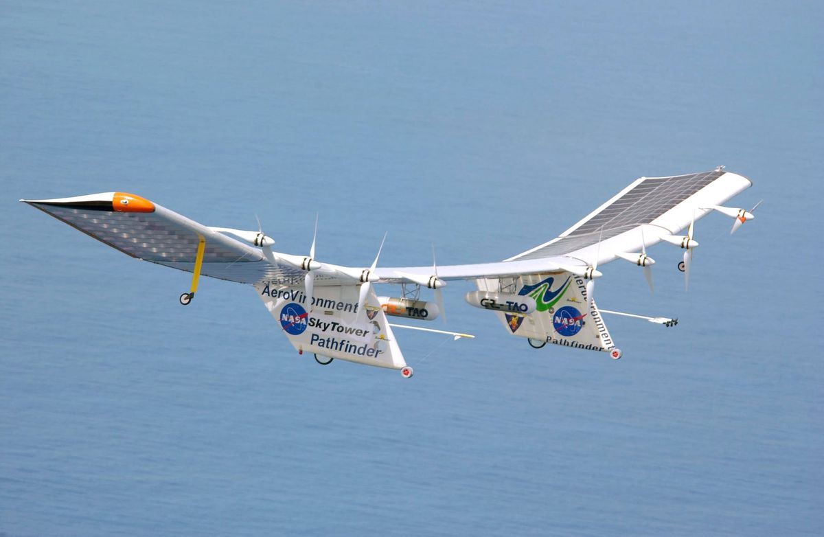
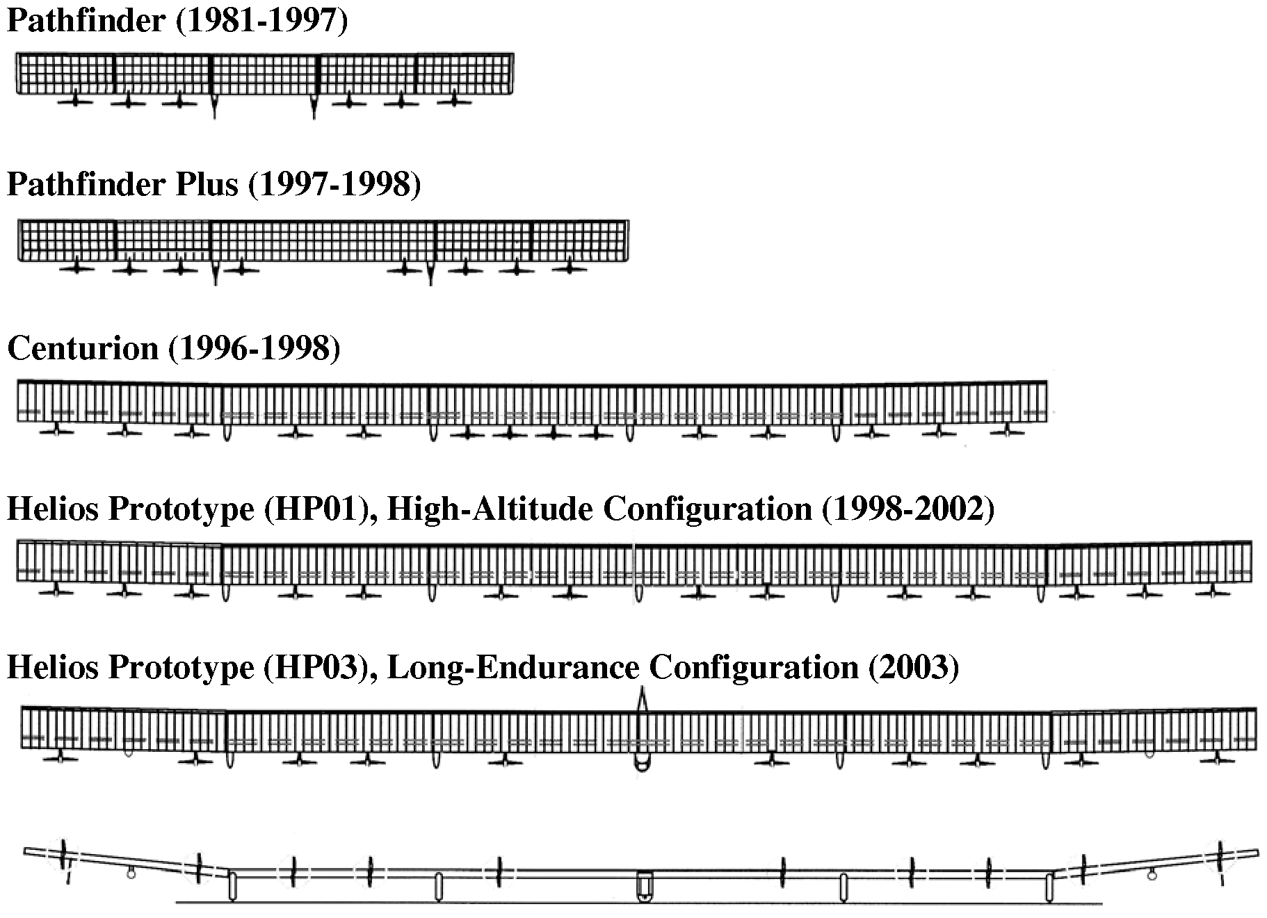
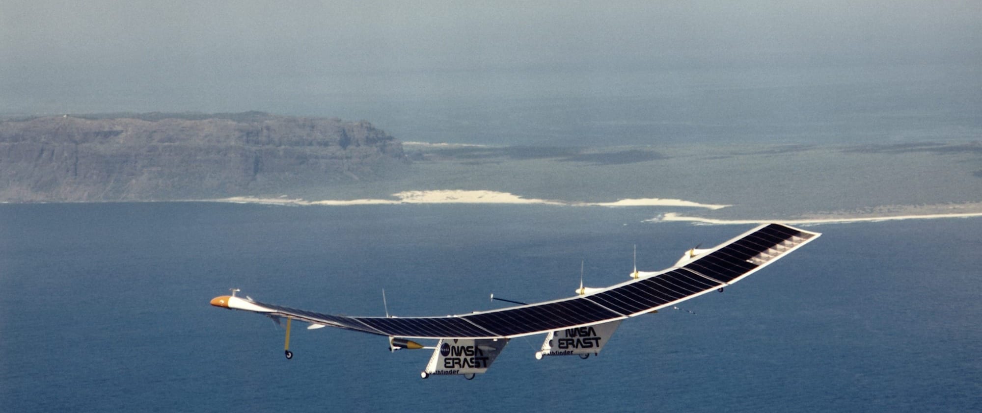
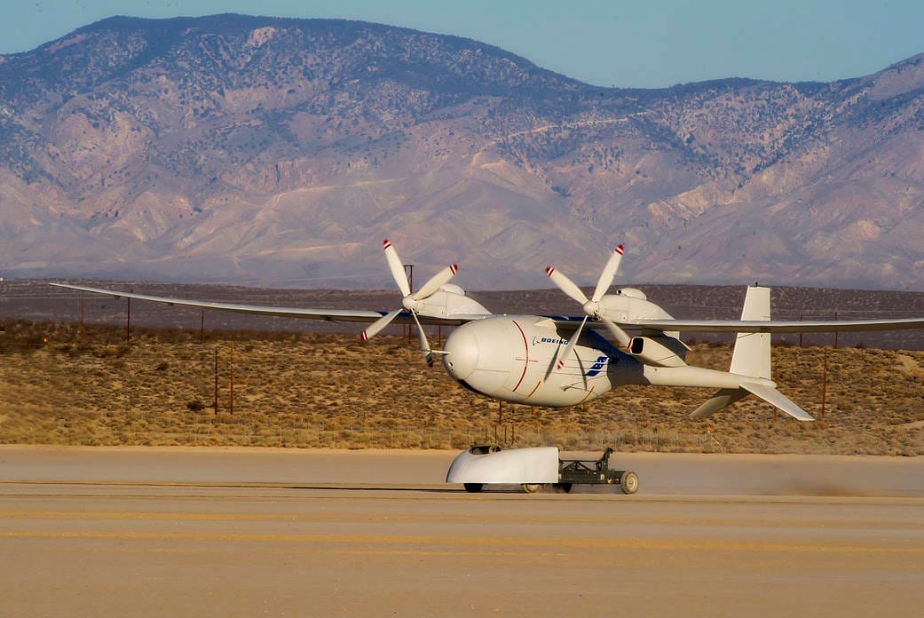
In practice, today’s HAPS market is split across three architectures. The first is the solar-powered fixed-wing aircraft represented by AALTO[5], an Airbus[6] subsidiary, whose Zephyr platform weighs about 75 kg, has a 25 m wingspan, operates up to roughly 80,000 ft, and has demonstrated 67 days of continuous stratospheric flight. The second is the large fixed-wing communications aircraft family associated with SoftBank[7], whose Sunglider is listed at 78 m wingspan, 110 km/h cruise speed, “several months” endurance, and payload capability up to 75 kg in recent stratospheric testing. The third is the lighter-than-air class, including systems from Sceye[8] and the earlier balloon architecture pioneered by Loon[9] under Alphabet[10]. [11]
The architecture logic is simple. A solar HAPS must close a daily energy cycle: solar generation by day, storage for night, and propulsion plus payload operation throughout. That makes the dominant design variables energy density, solar efficiency, mass fraction, aerodynamic efficiency, and propulsion power for station-keeping. Communications missions add service-link antennas, feeder links, beamforming, and a ground gateway; sensing missions add optical, hyperspectral, infrared, AIS, or other payloads plus onboard storage and a low-latency downlink. Because every kilogram and every watt matter, HAPS are fundamentally SWaP-limited systems. [12]
This SWaP logic explains why HAPS occupy a distinct position between satellites and towers. Satellites buy coverage with orbital mechanics and launch cost; terrestrial networks buy capacity with dense infrastructure and backhaul. HAPS buy persistence over one region using stratospheric loiter, but only within a relatively tight energy and payload envelope. That is why they are better understood as regional infrastructure nodes than as “cheap satellites.” [13]
Technical Performance and Constraints
The main technical advantage of HAPS is geometry. A HAPS service link is much closer to the user than a satellite link, and current HAPS telecom studies center on practical service areas of about 100 km radius, direct-to-handset operation in 4G/5G bands, and radio-link latency around 10 ms. A 2025 HAPS Alliance reference architecture puts low-, medium-, and high-capacity HAPS footprints at 100 km radius with throughput ranges from roughly 10–500 Mbps, 500 Mbps–5 Gbps, and 5–50 Gbps respectively, while noting that higher-capacity payloads require 30–150 kg of payload mass and progressively larger power budgets. SoftBank’s 2025 field trial, using a surrogate aircraft at 3,000 m, explicitly targeted an eventual HAPS service area up to 200 km in diameter and demonstrated average downlink throughput of about 33 Mbps under edge-of-coverage-equivalent conditions. [14]
The constraint is that those figures are not free. The same HAPS Alliance analysis estimates low-capacity service-link payloads at roughly 100–500 W, medium at 500–1,000 W, and high at 1,000–2,000 W, with overall platform power below 1 kW, below 3 kW, and above 3 kW for the three notional classes. That is precisely where fixed-wing solar HAPS become stressed: higher telecom throughput requires larger arrays, more RF power, more feeder-link capacity, more thermal management, and more structural margin, all of which compete against endurance. In other words, HAPS can offer good latency and useful regional capacity, but not with the effortless scaling associated with fiber-fed terrestrial macro layers. [15]
Atmospheric reality is the second binding constraint. The stratosphere is calmer than the troposphere, but it is not benign. Current HAPS literature and defense-readiness work emphasize sensitivity to stratospheric winds, low air density, surface conditions during launch and recovery, and the operational demands of solar-power management. AALTO’s payload specification for Zephyr assumes an environment up to 80,000 ft with temperatures between about -80°C and +60°C, while its 2025 record flight highlighted the challenge of crossing multiple flight information regions and the Intertropical Convergence Zone. These are not laboratory conditions; they are operational limits that shape mission availability and insurance, maintenance, and recovery planning. [16]
Coverage claims also need discipline. A HAPS may have a very large visual horizon, but usable telecom coverage is set by handset power, frequency, antenna gain, beam planning, feeder-link architecture, and regulatory constraints. Current sector documents consistently converge on about 100 km practical service radius, while feeder links from HAPS to ground are described as limited to roughly 50–100 km unless the network is extended through other HAPS or satellites. That means regional coverage is feasible, but continental coverage would still require many nodes, careful routing, and multiple gateways. [17]
For Earth observation, HAPS offer a different performance profile. Airbus states that its Strat-Observer payload can typically cover 2,500 km² per day at 18 cm resolution from the stratosphere, and a related Airbus presentation describes multi-sensor architectures with 18 cm RGB imaging, wider-area cameras, onboard 1 TB storage, high-rate line-of-sight transmission, and AIS ship detection at more than 400 km radius. The value proposition is persistence and task capability over one area, not the global revisit logic of satellites. [18]
For navigation augmentation, the technology is promising but pre-operational. A 2023 HAPS-aided GPS study found that adding HAPS ranging sources improved HDOP, VDOP, and 3D positioning accuracy in both suburban and dense urban environments; in field and simulated results, the 90th-percentile 3D positioning accuracy improved by about 36 percent in a suburban setting and 33.64 percent in a dense urban setting without RAIM, while a HAPS-aided RAIM configuration improved dense-urban 90th-percentile 3D accuracy by 45.2 percent. A 2026 follow-on optimization study framed HAPS deployment as a minimum-node placement problem under a 20 m CRLB threshold, reinforcing the idea that the most realistic role is regional augmentation over hard urban or contingency areas rather than full replacement of MEO GNSS. [19]
Economic Model and Cost Structure
HAPS economics remain highly scenario-dependent, and that is one of the most important investor and policy caveats. A 2024 IEEE techno-economic comparison modeled indicative total cost of ownership at about $4.371 million for a HAPS, versus $1.46 million for a LEO satellite and $0.0089 million for a tactical UAV, with the modeled HAPS carrying about $4 million in manufacturing CAPEX, 20-year life assumptions, and annual OPEX near $0.23 million. That model is stylized rather than vendor-specific, but its directional lesson is robust: HAPS are not low-cost in absolute terms, and the business case depends on matching them to the right coverage problem, not on assuming that “airplanes are cheaper than satellites.” [20]
The strongest economic case appears where terrestrial build-out is structurally inefficient. A 2025 white paper from the HAPS Alliance [21] gives a concrete Japanese example: to cover a 100 km radius area in Hokkaido with terrestrial infrastructure, about 1,600 ground base stations would be needed, with an estimated 10-year TCO of $445 million. In that scenario, the implied monthly cost per eligible customer was about $150, above the cited Japanese ARPU range of $40–70, making a purely terrestrial solution economically unattractive. The significance of that example is not that one HAPS automatically wins every rural case, but that HAPS can collapse the economics of dispersed, non-contiguous white spots where towers and backhaul are the dominant cost burden. [22]
That same logic extends to maritime zones, islands, mining and energy corridors, and disaster recovery. In all of those cases, HAPS benefit from avoiding heavy civil works and from being recoverable and relocatable, unlike satellites. But the economic downside is equally important: the fleet must still be procured, launched, recovered, insured, maintained, and staffed; gateways and spectrum still cost money; and utilization risk is high if the platform is not flown enough to amortize the fixed cost. The demise of Loon remains the clearest cautionary case: the platform delivered technical firsts and real emergency connectivity, yet the company concluded it could not drive cost low enough to support a sustainable long-term business. [23]
Use Cases and Deployment Scenarios
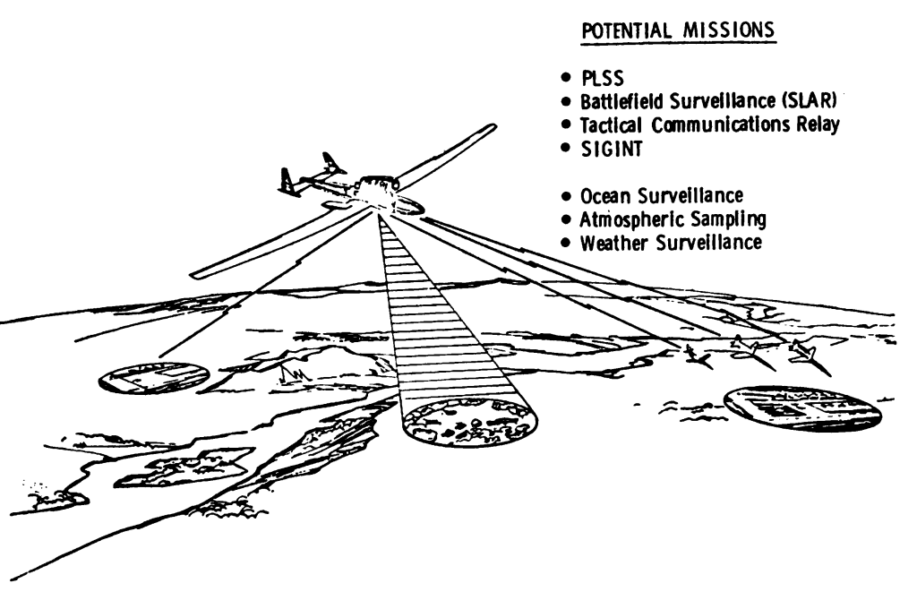
The commercial use cases that look most realistic through the late 2020s are telecom extension, backhaul, and service restoration. For this utility, momentum is strongest in Japan [24] and Kenya [25]. AALTO completed a 4G handset connection from Zephyr in Kenya in 2025 and linked that milestone to targeted commercial entry into service in Japan in 2026. SoftBank has separately stated that it plans pre-commercial HAPS telecom services in Japan in 2026 and, in its 2025 trial, demonstrated six-cell end-to-end 5G connectivity using standard mobile-network bands and beam control. These are meaningful markers because they move HAPS from generic “connectivity” claims toward operator-grade network integration and service-link/feeder-link design. [26]
For Earth observation and environmental monitoring, HAPS are most compelling where persistence matters more than global revisit. NASA [27] has described HAPS as a unique vantage point for mission-critical measurements requiring high spatial and temporal resolution, and its current activities include wildfire communications and imaging experiments plus multiple HAPS-related SBIR efforts. United States Geological Survey [28] and NASA also partnered with Sceye on climate and disaster monitoring work focused on methane “super emitters,” wildfire activity, storms, and earthquakes. These are missions where satellites often lack continuity over one target, crewed aircraft are expensive, and tactical drones lack persistence. [29]
Defense and security use cases are more mature conceptually than commercially. Open public material on the European High Atmosphere Airship Platform identifies dual-use roles including communication relay, missile warning, and ISR. AALTO explicitly markets Zephyr into government ISR and C4I missions, and French higher-airspace strategy documents and reporting show that Europe is now treating very-high-altitude systems as a strategic domain rather than a curiosity. That makes HAPS especially relevant for persistent border surveillance, communications relay, maritime monitoring, and contingency coverage in areas where terrestrial infrastructure is contested or deliberately targeted. [30]
The dual-use overlap is therefore substantial. The same platform that restores rural service can provide situational awareness; the same optical payload that maps crops can detect shipping, fires, or force movement; and the same regional positioning augmentation that helps resilience can support defense mobility. That overlap strengthens the industrial case but also ensures that export control, procurement, and civil-military governance will shape the sector as much as engineering does. [31]
Position in the Infrastructure Stack
Compared with SpaceX [32]’s Starlink [33] and Eutelsat OneWeb [34], HAPS have a simpler regional geometry and lower radio-link latency, and they can use ordinary mobile spectrum and user devices under the new HIBS framework. Starlink describes its first-generation system at about 550 km altitude, OneWeb operates at about 1,200 km, and GPS/Galileo MEO systems sit around 20,200 km and 23,222 km respectively. HAPS service links, by contrast, are measured in tens of kilometers. This makes HAPS particularly strong where power budget, Doppler, and edge latency matter, but much weaker where global continuity, oceanic breadth, and scale economics dominate. [35]
Against GEO systems, the comparison is sharper. HAPS Alliance technical assumptions place HAPS radio-link latency near 10 ms, LEO near 50 ms, and GEO near 500 ms. In addition, GEO’s physics make direct-to-handset broadband harder without larger terminals or narrower service models. HAPS therefore outperform GEO for low-latency regional broadband, responsive sensing, and rapid re-tasking. But GEO still wins on continental beam reach, mature business models, and broad-area broadcasting or trunking where latency is secondary. [36]
Against fiber and terrestrial mobile networks, HAPS are structurally disadvantaged in dense markets. Fiber-backed terrestrial cells remain the cheapest and highest-capacity answer where roads, power, and backhaul exist. HAPS cannot match the spectral reuse, capacity density, or maintenance familiarity of a mature ground network in cities and suburbs. Their comparative advantage begins where terrestrial economics break down: sparse road networks, mountains, remote islands, maritime approaches, or major post-disaster outages. [37]
The best systems-level conclusion is therefore differentiated. HAPS are superior for rapidly deployable regional persistence, sparse-area coverage, and low-latency sensing/relay above difficult terrain. They are complementary to LEO satellites for backhaul and multilayer NTN architectures, and complementary to terrestrial networks for disaster recovery and white-spot reduction. They are structurally disadvantaged against fiber and dense terrestrial networks for mainstream broadband, and against LEO/GEO systems for global-scale economics and reach. [38]
Governance, Security, and Outlook
Regulation is moving from conceptual debate to implementation. The sovereign baseline remains straightforward: the Chicago Convention says states have complete and exclusive sovereignty over the airspace above their territory. At the same time, the broader legal boundary between airspace and outer space is still not precisely defined in international law, and UN material shows that delimitation remains debated. For today’s HAPS, however, this ambiguity is less about whether 18–25 km is sovereign airspace (it is) but more about how to build long-duration, cross-border, higher-airspace traffic rules without fragmenting the market. That is why the European Union Aviation Safety Agency [39] is building a 2024–2027 draft HAO framework for the European Union [40], and why the International Civil Aviation Organization [41] has warned that a fragmented state-by-state approach would inhibit growth and compromise safety. [42]
Spectrum has also advanced materially. WRC-23 created new identifications and conditions for HAPS as IMT base stations in low-band, 1.7/2.1 GHz, and 2.6 GHz mobile spectrum, while also imposing incumbent-protection conditions and directional limits in some bands. That is strategically important because it enables HIBS to use standard mobile frequencies and devices, but it does not eliminate interference management, cross-border coordination, or feeder-link weather constraints. The same technical work that enables HAPS also underscores the need for site diversity and multilayer backhaul because feeder links alone are often limited to roughly 50–100 km. [43]
Security and export-control implications are not ancillary; they are central. HAPS are inherently dual-use because the same platform can host telecom payloads, imaging sensors, navigation augmentation, and military relay or ISR functions. The EU’s dual-use regime, the Wassenaar framework, and updated U.S. UAV export rules show that the industrial base already sits inside a tightening control environment for dual-use and long-range uncrewed systems. For operators, that means supply chains, encryption, sensors, navigation modules, and communications payloads may become as decisive as the platform itself. [44]
The risk register should be read candidly. The first risk is technical underdelivery: endurance records do not automatically translate into commercial availability, especially once payloads become heavier and more power-hungry. The second is operational fragility: launch, recovery, and weather windows still matter, and even stratospheric station-keeping remains wind-sensitive. The third is economic competition: LEO systems are improving rapidly, and they keep gaining scale, financing, and regulatory momentum. The fourth is governance and cyber risk: a HAPS fleet is part aircraft, part telecom network, and part critical digital infrastructure, which complicates certification and security assurance. The fifth is payload insufficiency: the very features that make HAPS attractive (persistence and regionality) do not overcome hard mass and power limits. [45]
Through 2035, the most visible public pipelines are in United States [46], Japan [24], and Europe, with France [47] pursuing heavier very-high-altitude security platforms and public commercial roadmaps in Japan targeting 2026. SoftBank and its partners also plan optical LEO-HAPS demonstrations around 2027, while official material around Stratobus points to late-decade industrialization. Open-source evidence for China[48] is less transparent on commercial HAPS deployment than in Japan or Europe, but Chinese academic work on pseudolite/GNSS augmentation and broader NTN policy activity suggest that Beijing is unlikely to ignore the stratospheric layer. The most plausible outcome is neither mass failure nor universal adoption: HAPS are likely to become a standard infrastructure option in selected regional, sovereign, and resilience-focused cases, while remaining a niche solution in mainstream mass-market broadband. [49]
Open Questions and Limitations
The largest unresolved issue is cost transparency. Public materials still provide only fragments of true commercial cost structure, and many headline economics rely on scenario modeling rather than audited program data. Reliability is another open question: endurance records are improving, but the industry still lacks long public histories of multi-platform commercial operations at scale. Navigation augmentation is technically promising, yet still mostly at the simulation and field-experiment stage rather than in fielded operational service. Finally, many military use cases are likely more advanced than the public record shows, which means the open-source picture probably understates both capability and regulatory sensitivity. [50]


Citations
[1] [6] [13] [20] [50]
Tóka, L., Kocsis, P., Biczók, G., & Pénzes, J. (2024). Techno-economic analysis of high-altitude platform systems for communication networks. CrySyS Lab. https://static.crysys.hu/v1/publications/files/TokaKPB2024Commag
[2] [3] [5] [46]
International Telecommunication Union. (n.d.). High-altitude platform systems (HAPS). https://www.itu.int/en/mediacentre/backgrounders/Pages/High-altitude-platform-systems.aspx
[4] [11] [12] [41]
AALTO HAPS Ltd. (2024). Be the interface: AALTO launches call to payload industry in Stratospace. https://www.aaltohaps.com/be-the-interface-aalto-launches-call-to-payload-industry-in-stratospace/
[7] [10] [14] [15] [17] [22] [25] [32] [33] [36] [37] [38] [39] [40] [47] [48]
HAPS Alliance. (2025). HAPS reference architecture and advantages for satellite connectivity (White paper). https://hapsalliance.org/wp-content/uploads/formidable/12/2025_HAPSAlliance_Reference_Architecture_Advantages_Satellite_Connectivity_TWG_Whitepaper_update.pdf
[8] [29] [34]
National Aeronautics and Space Administration. (2025). SCOAR: Stratospheric communications and observation architecture report. https://ntrs.nasa.gov/api/citations/20250003771/downloads/SCOAR%202025%20APR%2025.pdf
[9] [35]
SpaceX. (n.d.). Starlink technology overview. https://www.starlink.com/technology
[16] [28] [45]
HAPS Alliance. (2025). HAPS defense technology readiness framework (White paper). https://hapsalliance.org/wp-content/uploads/formidable/12/haps-defense-technology-readiness-framework-white-paper-2025.pdf
[18]
Airbus. (n.d.). Zephyr high-altitude pseudo-satellite (HAPS). https://www.airbus.com/en/products-services/defence/uas/zephyr
[19]
Zhang, X., et al. (2023). HAPS-aided GPS positioning performance analysis (arXiv preprint). https://arxiv.org/pdf/2301.00758
[21] [30]
Permanent Structured Cooperation (PESCO). (n.d.). European high atmosphere airship platform (EHAAP). https://www.pesco.europa.eu/project/european-high-atmosphere-airship-platform-ehaap-persistent-intelligence-surveillance-and-reconnaissance-isr-capability/
[23]
X Development LLC. (n.d.). Project Loon. https://x.company/projects/loon/
[24] [49]
SoftBank Corp. (2025). SoftBank announces HAPS development and deployment plans (Press release). https://www.softbank.jp/en/corp/news/press/sbkk/2025/20250626_01/
[26]
AALTO HAPS Ltd. (2025). Zephyr conducts stratospheric connectivity test in Kenya connecting 4G mobile device to HAPS. https://www.aaltohaps.com/wp-content/uploads/2025/02/Zephyr-conducts-stratospheric-connectivity-test-in-Kenya-connecting-4G-mobile-device-to-HAPS.pdf
[27] [31]
Bourdon, J. (2024). High-altitude platforms and the future of telecommunications infrastructure. Annales des Mines – Enjeux Numériques. https://www.annales.org/enjeux-numeriques/2024/en-2024-03/2024-03-04.pdf
[42]
International Civil Aviation Organization. (2025). Convention on International Civil Aviation (Chicago Convention). https://www.icao.int/sites/default/files/2025-02/7300_orig.pdf
[43]
International Telecommunication Union Radiocommunication Sector. (2023). HAPS spectrum and regulatory framework update. https://www.itu.int/dms_pub/itu-r/md/00/cr/cir/R00-CR-CIR-0509!!PDF-E.pdf
[44]
European Commission. (2025). 2025 update of the EU control list of dual-use items. https://policy.trade.ec.europa.eu/news/2025-update-eu-control-list-dual-use-items-2025-09-08_en